Oakland’s Spring-Like Heat Wave Fades as High Surf and Clouds Roll In
Oakland’s Spring-Like Heat Wave Fades as High Surf and Clouds Roll In
Residents across Oakland are waking up to a notable shift in the weather this Friday, February 6, 2026, as the record-breaking warmth of the past few days begins to subside. While the week started with temperatures more reminiscent of May than February—including a near-record high of 71 degrees reached on Wednesday—a cooling trend is officially moving into the East Bay. Meteorologists indicate that the ridge of high pressure responsible for the unseasonable heat is finally beginning to fade, making way for a more typical winter pattern.
Morning: Hazy Skies and Crisp Air
The morning hours in Oakland will feature lingering haze and patchy fog, particularly in the lower elevations near the San Francisco Bay and the Estuary. Early commuters can expect temperatures starting in the low 50s. While the atmospheric stagnation that characterized earlier in the week is still present, the haze is expected to thin by mid-morning. This will give way to high-altitude clouds that will filter the sunlight, creating a muted, silver-toned sky for the start of the workday.
Afternoon: Cooler Highs and Increasing Cloud Cover
By the afternoon, the peak temperatures will be significantly lower than the highs seen earlier this week. Today’s high in Oakland is expected to reach approximately 65°F to 67°F. While this remains slightly above the historical February average, it marks the start of a cooling pattern leading into the weekend. High-level clouds will continue to stream across the skies, providing a break from the direct sun. Winds are expected to remain light inland, though a steady sea breeze may develop near the Port of Oakland and Jack London Square by late afternoon, bringing a cooler, damp feel to the air.
Evening: A Chilly Transition
As the sun sets, temperatures will drop steadily, reaching an overnight low of approximately 51°F. The sky will transition from partly cloudy to mostly cloudy as moisture levels increase ahead of a weak system moving toward the coast. Humidity is expected to hover around 75% to 80% tonight. For those planning to attend outdoor events or visit the various dining districts in Uptown or Rockridge, a medium-weight jacket is recommended to combat the evening chill.
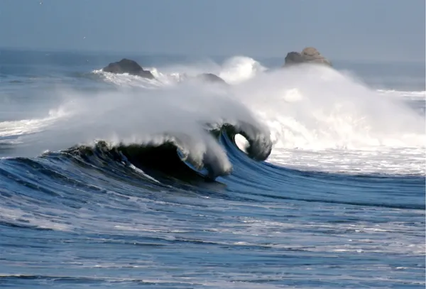
Special Warnings: High Surf and Coastal Hazards
While the weather inland remains calm, the National Weather Service has issued a High Surf Advisory for the Pacific Coast beaches just west of Oakland. Breaking waves of 17 to 22 feet are expected through Saturday night. Although Oakland’s inner shoreline is protected, residents are urged to use extreme caution if traveling to coastal areas this weekend. Dangerous sneaker waves and rip currents are a major concern. Looking ahead, while Friday will remain dry, the cooling trend will continue with shower chances returning to the regional forecast by Sunday evening.